Showing all 3 results
Categories: FlightHub 2
DJI FlightHub 2
€218.00 - €1,132.00
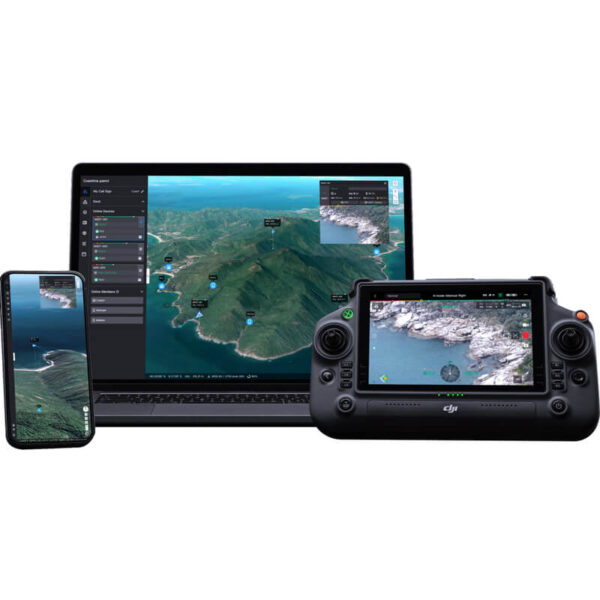
DJI FlightHub 2 is an all-in-one cloud-based drone operations management platform that helps you to achieve comprehensive, real-time situational awareness. Access all of the information you need to plan drone missions, supervise your fleet, and manage the data you create, now from a secure cloud-based environment.
- FlightHub 2 provides the global 2.5D Base Map; supports viewing mission livestreams and panorama photos in real time on the cloud; and can generate RGB or infrared orthomosaic maps, granting you detailed awareness of your mission environment when needed.
- FlightHub 2 supports multi-device data annotation and real-time synchronization, allowing you to highlight objects, plan flight routes, and more. You can also synchronize team positions, mission details, and map information in real time, making team collaboration easier than ever.
- Create a variety of flight missions directly from your computer using the 2.5D Base Map. Preview expected results for each mission point, ensuring flight route safety and data quality. Synchronize missions with pilots for efficient and convenient execution.
- Review operation results on the cloud. Open any captured photo, video, or panorama, and it will be displayed on the 2.5D Base Map along with corresponding coordinate information.
- When used with DJI Dock, FlightHub 2 supports remote drone operations, including flight scheduling, automatic task execution, and media uploading and storage; it can also achieve centralized equipment operation and maintenance, including abnormal alerts and remote maintenance.
Categories: Modify
DJI Modify Standard Permanent
€1,586.00
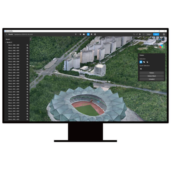
DJI Modify is DJI's first intelligent 3D model editing software. It features a streamlined and intuitive interface that makes it simple to complete model editing efficiently. [1]Paired with a DJI Enterprise drone and DJI Terra, it forms a comprehensive solution from aerial surveying, modeling, and model editing to sharing these models easily to meet operational needs in surveying and mapping, firefighting, emergency response, and transportation.[2]
- Seamless workflow: DJI Modify can work with DJI Terra in a seamless workflow. In a DJI Terra modeling project, you can launch DJI Modify with one click for model editing. This achieves an efficient workflow between DJI Terra and DJI Modify.[3]
- Streamlined interaction: Without the need for complex settings, DJI Modify supports fast import and export of model files and batch editing of multiple models, significantly reducing the model editing workload.
- Efficient model repair: DJI Modify supports various editing functions such as floating parts removal, surface flattening, texture repair, hole fill, and water surface repair, providing well-edited models at high efficiency.
- Quick delivery: DJI Modify allows you to export model files in a variety of formats compatible with DJI Terra or third-party software, including ply, obj, and b3dm. Processed models can be quickly shared to the cloud.
- Authorization modes[4]: Online authorization is supported.[5]
Categories: Terra
DJI Terra
€2,210.00 - €22,792.00
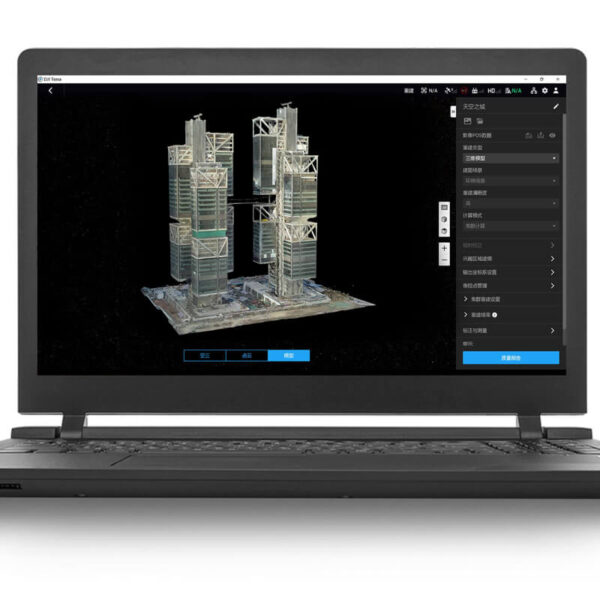
DJI Terra is 3D reconstruction software[1]that has photogrammetry as its core technology. It supports a range of accurate and efficient 2D and 3D reconstruction of visible light, and data processing through DJI LiDAR. DJI Terra is a perfect match for DJI Enterprise drones and payloads as well as DJI Modify[2] It works in conjunction to build a complete application solution that caters to verticals such as land surveying and mapping, power transmission, emergency services, construction, transportation, and agriculture.
- 2D and 3D visible light reconstruction[3]: You can import raw aerial photos to obtain a high-precision 2D orthophoto map and a real-scene 3D model.
- LiDAR data processing: When working with the DJI Zenmuse LiDAR, DJI Terra can generate high-precision results such as true-color point clouds and point cloud classification with one click.
- Multispectral reconstruction[4]: DJI Terra supports radiometric correction and reflectance map outputs for scientific research of remote sensing. It can also generate vegetation index maps such as NDVI and NDRE.
- Real-time reconstruction[5]: DJI Terra can generate 2D orthophoto maps or 3D models in real time during flights and outputs results as the drone flies.
- Detailed inspection[6]: DJI Terra can automatically generate executable inspection flight routes after target points are added based on a model or point clouds. This way, the inspection process is automated.
- Model application: DJI Terra allows you to easily measure objects' coordinates, distances, areas, volumes, and other key data and rename and export the data results.
- Authorization modes[7]: Online authorization[8] and offline authorization are supported.