
AGRICULTURE & FARMING · RTK & REPEAT VISITS
Choose an agricultural positioning workflow before buying a base station. This guide covers the confirmed Irish Drone Mavic 3M packages and the checks that make repeated capture useful.
Evidence reviewed 3 November 2026 · Ireland
The practical answer
Consider AG-02 when you need your own managed field-base workflow and can maintain its coordinate reference across visits. AG-01 has the same Mavic 3M and four total flight batteries; a suitable existing network-correction arrangement may avoid the need to buy a base. Neither package includes processing software. Validate the finished output: RTK positioning is not proof of map accuracy, reflectance calibration or an agronomic diagnosis.
Buy for the positioning workflow you will actually use
For an Irish grower, adviser or research team, the useful question is whether each survey must return to a dependable coordinate reference. A coloured crop map may help you choose where to walk; comparing small plots across dates, transferring observations to another system or measuring change puts a greater burden on positioning and validation.
Start by naming the output, the acceptable uncertainty and who will check it. Then choose the correction source. Owning a base can be useful where you want a field-controlled setup, but it also creates setup, coordinate-management and quality-checking work.
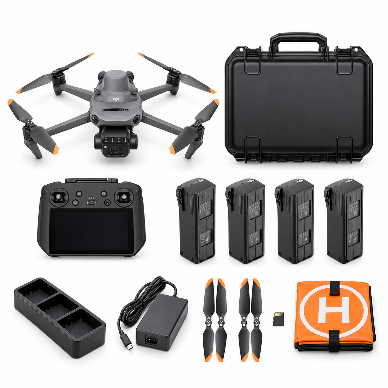
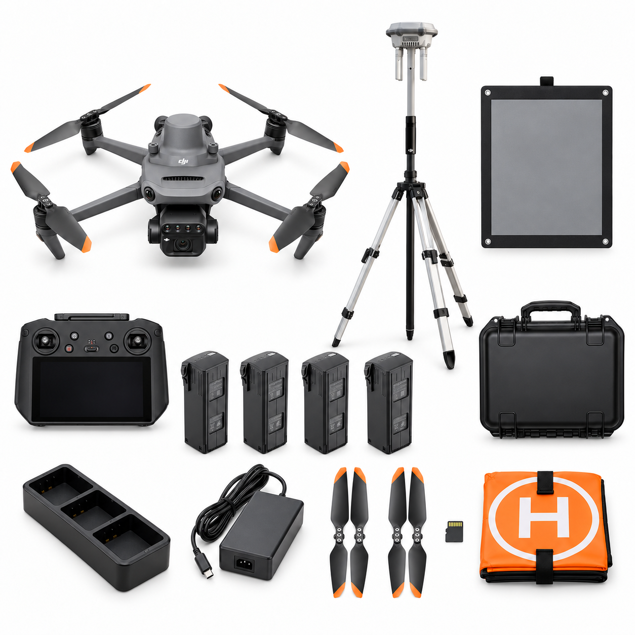
AG-01 and AG-02: the same aircraft, different field equipment
| Decision | AG-01 | AG-02 |
|---|---|---|
| Aircraft and flight batteries | Mavic 3M; four batteries total | The same Mavic 3M; four batteries total |
| Own base-station equipment | No D-RTK 3 included | D-RTK 3 Multifunctional Station, survey pole and tripod kit |
| Reflectance reference | No panel listed | Compatible calibrated reflectance panel; exact specification to confirm |
| Processing licence | Not included | Not included |
| Buying question | Do our existing correction and processing arrangements cover the job? | Do we need our own repeatable base-and-capture workflow? |
AG-01 is not a different, non-RTK aircraft. The Mavic 3M includes its RTK module. [3] AG-02 also has a larger training/support provision and a first-project dataset review; agree the current service scope before ordering.
Verify the exact station, mode and firmware
DJI’s current support table explicitly includes Mavic 3M with D-RTK 3. [1] Use the Multifunctional Station in Base Station/Broadcast mode. The Mavic 3 family is not on DJI’s relay-mode list, and its base compatibility carries a manual coordinate-calibration qualification. [2]
The separate Relay Fixed Deployment version is not an interchangeable agricultural base purchase. [13] Ask the supplier to demonstrate the intended combination, rather than accepting a demonstration with another aircraft. DJI’s older M3M FAQ mentions D-RTK 2; that answer alone does not describe today’s full compatibility. [3]
Keep a record of the aircraft, controller and station firmware delivered with your equipment. Check the manufacturer release notes before updating, and confirm that the intended connection still works after a change. [6] [7]

A local base is an alternative to network corrections
Mavic 3M can use network RTK through controller Wi-Fi. [3] If your team already has a suitable service, test its credentials, correction delivery and connection at the actual fields. An AG-01 workflow may then be sufficient. A phone hotspot working at the farmhouse is not a field acceptance test.
AG-02 is worth considering when an owned local correction source fits the programme. However, broadcasting corrections and knowing the base’s coordinates are different tasks. DJI distinguishes uncalibrated, satellite-based and network-calibrated station coordinates. [4] An uncalibrated base is not automatically a surveyed reference.
For repeat visits, document how the base position is established, which coordinate reference is used, and how the next survey will reproduce it. Have the supplier demonstrate this with the supplied controller and station. Do not assume another controller is included, or that a Matrice demonstration proves an identical Mavic workflow.
Make repeat capture a documented field procedure
Before the first season, agree a small representative trial and a written acceptance check. The following is an editorial planning checklist, not a universal flight prescription:
- Keep a field record. Name the parcel, crop stage, date, recent operations and the comparison you intend to make.
- Keep the reference reproducible. Record the base location, coordinate source and any survey reference used. Photograph its setup.
- Keep the station stable. Use an open, stable position and follow the manufacturer’s setup instructions. [5]
- Check the capture. Preserve original images and review the RTK metadata for interruptions or non-fixed solutions. DJI documents these status fields. [8]
- Check the output independently. Agree suitable checkpoints and acceptance tolerances before processing, then retain their residuals with the report.
RTK camera positions are not independent validation of the finished map. Separate checkpoints help reveal remaining errors; a consistent reference matters across dates. [10] A University of Porto M3M study also examines camera-calibration and acquisition choices, illustrating why the receiver specification alone cannot establish product accuracy. [11]
Positioning and reflectance calibration solve different problems
RTK concerns where an observation belongs. Radiometric processing concerns what the recorded spectral values mean. The WheatCAP university protocol treats georeferencing and reflectance calibration separately. [9] Therefore, adding a base does not calibrate NDVI or turn a vegetation index into a crop diagnosis.
AG-02 lists a compatible calibrated reflectance panel. Before supply, confirm its make, spectral reference values, certificate or reference file, condition requirements and compatibility with your chosen processor. Its unspecified model cannot justify invented reflectance percentages or a claimed calibration accuracy. A calibration panel is also not automatically a surveyed ground-control target.
For seasonal comparisons, agree a consistent illumination and calibration protocol with the analyst. Record deviations and retain the reference captures they require. Investigate an unexpected pattern in the field before making a management decision. The package does not include agronomic diagnosis, and a dataset review should not be described as one.
What to check before accepting the package
- Demonstrate the exact link. Show this Mavic 3M receiving the intended corrections and explain how the base coordinates were established.
- Demonstrate maintenance. Agree activation, updates and recovery steps. The station manual provides Assistant 2 as an update route. [5]
- Demonstrate the data handover. Process a small customer-supplied sample in the intended software, identify any additional licence or correction-service requirements, and document export formats.
- Define acceptance. Name the reviewer, checkpoint test and action if capture conditions or positioning quality fail.
Confirm access, flight planning and applicable Irish operating requirements separately. A base station does not change the permission required for the flight or make an obscured survey safe.
Questions before choosing AG-02
Will AG-02 guarantee centimetre-accurate maps?
No. Agree a deliverable-specific validation test. Receiver positioning, image geometry and the processed output are different things.
Can one station be the base and collect checkpoints at the same time?
Plan these as separate operations. Do not move an active base around to measure points during its capture mission. [13] Confirm how independent control will be obtained.
Is processing software included?
No. Both packages require customer-supplied processing software. Buying the panel or station does not add a licence.
Should every farm buy a base?
No. Test the required output and your existing correction arrangements first. The right choice follows the field workflow, not the package name.
Compare the two confirmed configurations
Review AG-01 Crop Monitoring Essential and AG-02 Crop Advisory Professional, then send Irish Drone your field locations and intended outputs. Include your existing correction service, processor and validation plan. We can discuss whether the D-RTK 3 Multifunctional Station adds useful capability to your Mavic 3 Multispectral workflow. Confirm the written included-items and service scope before ordering.
Explore the agriculture packages on Irish Drone
Official manuals and setup guidance
Continue with the guide for your farm
Documentation and evidence
Use the current instructions for the selected equipment and the requirements of your actual operation.
Technical sources and scope
- DJI Help Centre: enterprise RTK support table
Compatibility evidence, not proof of the delivered Irish firmware or every station mode. Reviewed 3 November 2026.
- DJI D-RTK 3: supported models and mode qualification
Mavic 3M explicit identity cross-checked against DJI-COMPAT. Do not promise relay capability or an automatic M4E-specific calibration/PPK workflow. Reviewed 3 November 2026.
- DJI Mavic 3M FAQ
The D-RTK 2 answer is not an exhaustive current D-RTK 3 exclusion. Network service availability, credentials and subscription are not included in AG packages. Reviewed 3 November 2026.
- DJI D-RTK 3 specifications
No rover or aircraft positioning figure is presented as whole-map, NDVI, boundary or agronomic accuracy. Reviewed 3 November 2026.
- D-RTK 3 Multifunctional Station UserManual v1.0
January2025 manual predates later firmware. No claim that one unit can act as stationary base and moving rover simultaneously. Reviewed 3 November 2026.
- Mavic 3 Enterprise Series ReleaseNotes, including3M, 7May2026
Records the presently listed release, not the minimum firmware that first enabled D-RTK 3. Reviewed 3 November 2026.
- D-RTK 3 ReleaseNotes, 16June2026
The general app addition does not remove the product-page manual-calibration qualification for Mavic 3 without demonstrating that exact delivered combination. Reviewed 3 November 2026.
- Mavic 3M ImageProcessing Guide v1.0
Metadata supports capture QA; a fixed flag does not independently validate the processed product or remove radiometric processing. Reviewed 3 November 2026.
- Texas A&M AgriLife–Purdue WheatCAP UAS workflow
Older platforms and US flight rules are not carried across to Mavic 3M or Irish legal requirements. No universal flight height or panel settings imported. Reviewed 3 November 2026.
- UAV soil-surface photogrammetry: georeferencing and independent validation
A measurement-method reference, not a Mavic 3M/D-RTK 3 crop trial or guaranteed error figure. Reviewed 3 November 2026.
- University of Porto: precise georeferencing of RGB and multispectral drone images
Estuary/built-up test settings, not an Irish crop trial; no numerical results transferred as package performance. Reviewed 3 November 2026.
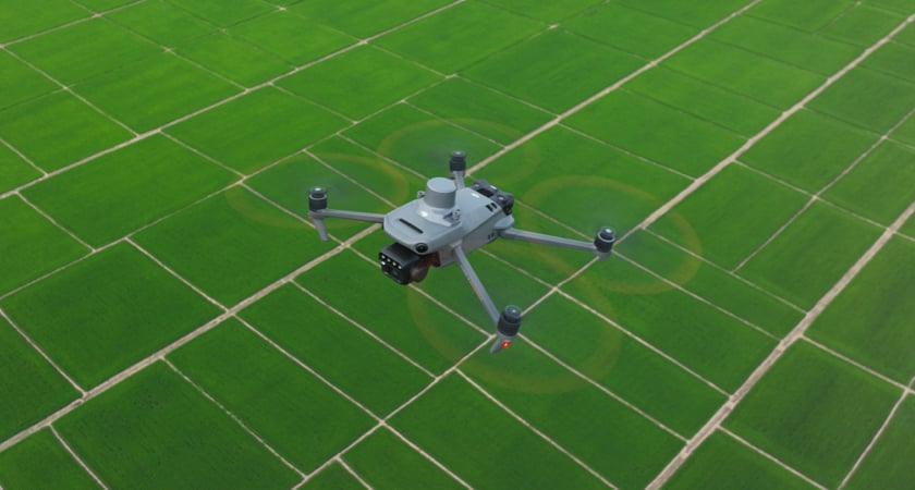
- DJI Mavic 3 Multispectral top features: agricultural application photograph
Manufacturer application visual, not an IrishDrone customer project or proof of RTK/NDVI output quality. Reviewed 3 November 2026.
- DJI D-RTK 3 FAQ: station versions and base movement
This is not Mavic 3 relay compatibility, nor a simultaneous moving-rover/stationary-base workflow. Reviewed 3 November 2026.




Pingback: Mavic 3M to Agras | Prescription Workflow Checks
Pingback: Matrice 4T for Livestock & Farm Checks | Irish Drone
Pingback: Mavic 3M Crop Monitoring: Capture, Process & Field-Check
Pingback: Agriculture Drones Ireland: Mavic 3M or Matrice 4T?