

The important handover is an agronomically reviewed, correctly located instruction that the exact application system can interpret.
Start with the decision that the map should support
A multispectral map is an observation product. An application prescription is an instruction. Moving from one to the other requires an explicit decision about what should happen in each part of the field and why. Agree the crop question, the intended use of the data and the person qualified to interpret it before commissioning an aerial survey. Otherwise a technically attractive map can arrive without a defensible treatment decision.
DJI documents a Mavic 3M, SmartFarm and Agras workflow in its T50 FAQ. That establishes a manufacturer-described pathway, not proof that every Agras controller, software edition or file revision accepts the same job. Our existing Mavic 3M monitoring and field-check guide covers observation in greater depth, while the D-RTK 3 crop-survey article examines the positioning decision. Here the focus is the chain of custody between capture, agronomic interpretation, prescription preparation and the application aircraft’s verified working file.
Keep the survey reference and field identity intact
Give the field and survey a unique identity. Record the capture date, crop stage, boundary version and relevant conditions, together with the coordinate reference and positioning approach used by the survey team. Retain the source photographs and processing settings needed to explain the result. Where RTK is used, record the correction source and the quality checks; a correction connection alone is not evidence that every output is correctly located.
The Mavic 3M support documentation describes mapping mission imports and terrain-follow data. These survey functions should not be confused with the application aircraft’s route or release controls. Compare the mapped boundary with current physical features and known points before passing data downstream. A hedge moved since the source imagery, a field divided by a temporary fence or an incorrectly selected boundary file can make a precise-looking product operationally wrong.
Ground-check the pattern before selecting an action
Investigate the reasons behind the mapped variation. A low vegetation-index area may require a different response from a superficially similar area elsewhere. Use field observations and the farm’s other evidence to distinguish plausible causes. Record uncertainty instead of forcing every colour band into a treatment zone. The purpose of the review is to decide whether an intervention is justified and what instruction can be defended.
Keep the observation layer separate from the approved prescription. The survey team can supply measurements and mapped differences; the responsible adviser defines the agronomic action and any applicable product constraints. Where the evidence supports no treatment, make that a deliberate decision. Where the cause is unresolved, create a follow-up task rather than treating the aircraft’s variable-rate capability as a reason to apply something. This decision record is especially important when a contractor receives a map from a third party.

Prepare a prescription with explicit units and limits
A usable handover identifies the material, units, intended rate zones, field boundary and areas excluded from application. Check how zero or no-data cells are interpreted and whether transitions between zones need special handling. Include a version identifier and the approving person’s name or role. Do not let a changed filename silently replace the meaning of a previously reviewed map.
The DJI Terra agricultural prescription guide describes reconstruction followed by prescription preparation and transfer to a compatible app. The SmartFarm Web guide also documents prescription-file handling and account sharing. Treat the documented formats and steps as requirements to verify against the actual software version, account, region and aircraft controller. Do not promise a universal import merely because the file has a familiar extension, or infer that a current subscription or cloud entitlement is included in a hardware purchase.
Prove the import on the exact controller
Run an end-to-end acceptance exercise using the proposed aircraft, controller, app and account. The operator should identify the correct field, open the intended prescription version and inspect the displayed units, zones and exclusions. Compare identifiable locations with the approved source. Ask what happens if the controller is offline, a map is revised or an older job remains in its download list.
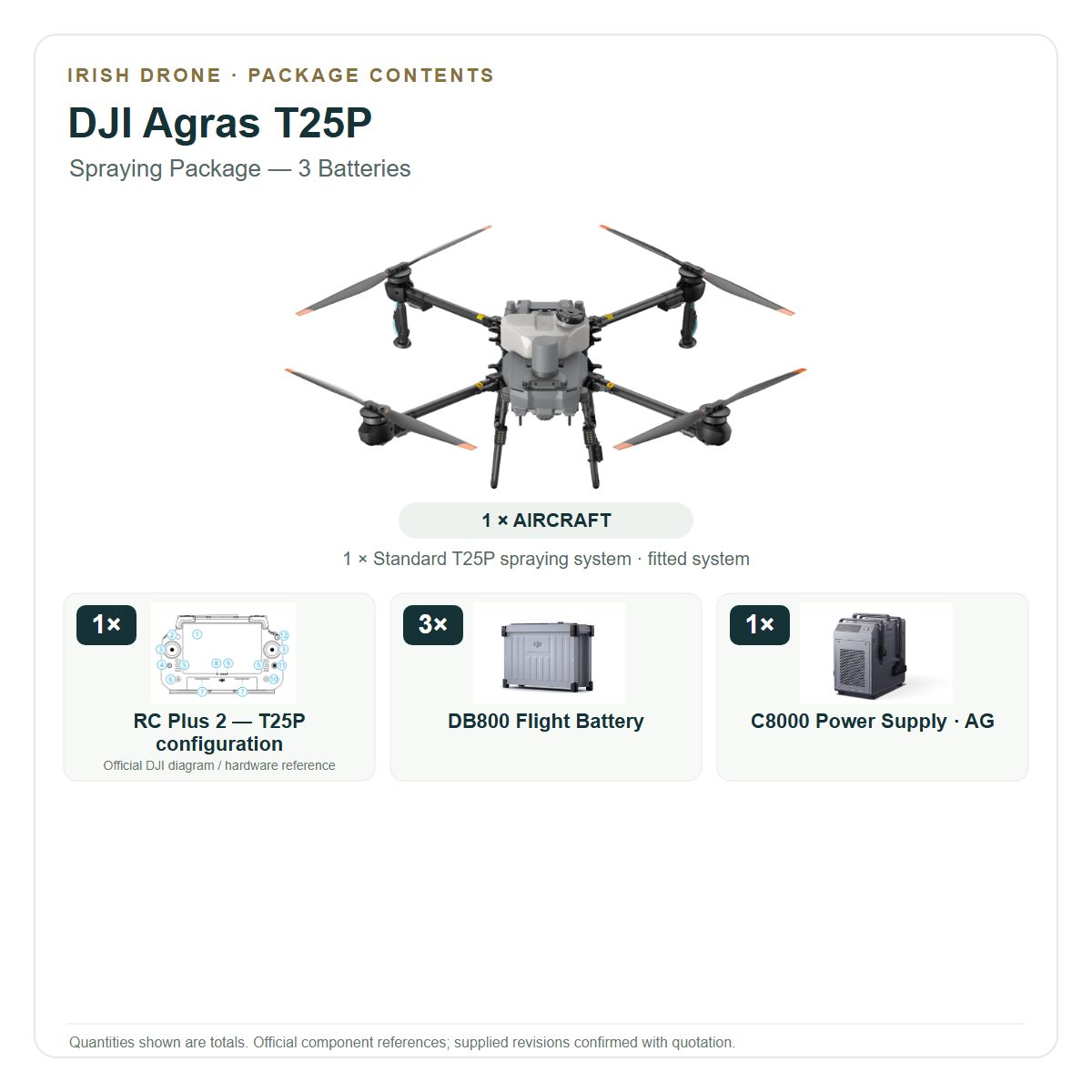
A successful transfer is more than an import-complete message. It should preserve the intended spatial reference and application meaning. Save screenshots or a suitable export showing the interpreted job, alongside the approved source file and the versions used. If the workflow cannot be demonstrated, retain the compatibility question as unresolved in the quotation. The T25P spraying package is a hardware configuration; it should not be described as including an untested processing licence, account entitlement or prescription integration.

Illustrative example: a map with a wet corner
Consider a hypothetical field where a recent survey shows a different vegetation pattern in one corner. This example does not prescribe a treatment. A field inspection finds that the corner has a different management or soil-water context from the rest of the field. The adviser records that evidence and decides whether the area needs follow-up, exclusion or a different instruction. The colour pattern is not converted automatically into a chemical or fertiliser decision.
The team then prepares a clearly versioned demonstration file. On the application controller, they verify the corner’s location, boundary and exclusion behaviour before any permitted release. If the mapped corner appears on the wrong side of a hedge, the job stops for data reconciliation. That simple spatial check can be more valuable than adding another layer of automated analysis. The final record explains both the agronomic decision and the exact software chain that carried it to the operator.
Test the application separately from the map
A correctly imported map does not calibrate the physical application system. The metering equipment still needs the appropriate checks for the liquid or granular material, and the aircraft’s actual configuration must match the job plan. Use clean-water trials where appropriate for a spraying-system assessment, and agreed material-specific tests for spreading. Separate the evidence of data interpretation from evidence of delivered distribution or deposition.
Keep the relevant exact-model operating and safety documentation with the commissioning record. Confirm how the operator pauses, resumes and closes a job, and how partial work is distinguished from completed work. The person reviewing the results should be able to identify the prescription version and any deviations. Avoid using a controller coverage display as the sole proof that the required material reached every intended target under the required conditions.
Build a reusable handover package
Retain the field identity, original survey, processing description, ground observations, approved prescription and controller acceptance evidence as linked records. Add the actual operating log and an explanation of any change made at the field. Use a clear naming system and a responsible person for issuing revisions. This allows a later repeat visit to start from a known decision rather than an unexplained image or an old controller download.
Before asking Irish Drone for a configuration quotation, bring a sample dataset and a description of the software and account arrangements already in use. Specify the acceptance test that the proposed equipment must pass. Choose the monitoring and application components separately, then verify the handover between them. The useful outcome is a workflow that can be explained and repeated, with compatibility and permission questions resolved before the farm depends on it.
Frequently asked questions
Does an NDVI map automatically become an approved prescription?
No. The observation needs agronomic interpretation, explicit instructions and a verified transfer to the exact application system.
Is every Agras compatible with every DJI Terra or SmartFarm export?
No universal compatibility is claimed. Demonstrate the actual aircraft/controller/app/account/version combination before relying on the workflow.
Explore the aircraft and packages
Follow the product page for the exact configuration and included equipment. Equipment selection and operating authorisation are separate parts of the project.


Talk to Irish Drone about your project
Send us the site, task, load or application material, intended operating pattern and available charging supply. We can help scope a suitable aircraft and package and discuss the preparation needed for an Irish operation.
Contact usPlan the next part of your operation
Official sources and technical guidance
These links support specific facts in the guide. Check the current revision and operating conditions when preparing a real project.



Leave a comment